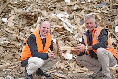
THE region’s $1.2b timber industry is set to tap into the world’s most sophisticated technology through an historic research agreement launched on Friday.
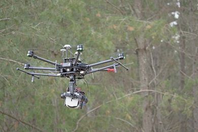
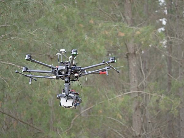
Researchers will use state-of-the-art drone technology to drive “significant gains” for the region’s timber production sector, which underpins thousands of jobs across the region.
The research deal is the first to flow from the newly created softwood research institute in Mount Gambier.
The hub – known as Forestry Research Mount Gambier – is being facilitated through the University of South Australia, which is an anchor partner.
Australian Forest Products Association chief executive officer Ross Hampton – who will fly to Mount Gambier today for the launch – said he was “delighted” the research hub was under way.
“This hub will undertake ground-breaking research – it will have national significance,” Mr Hampton said.
“This will drive innovation. The Green Triangle, which is one of Australia’s premier wood baskets – is in the box seat to take advantage of any developments.”
Importantly, he said the new hub would drive growth for the traditional timber production sector, as well as new technologies in biofuels and bioplastics made from wood fibre.
Member for Barker and co-convenor of the Parliamentary Friends of Forestry and Forest Products Tony Pasin said the collaboration would strengthen ties between research institutions and the sector’s strategic needs.
“By building on South Australia’s long tradition of plantation forests, and by making the most of local knowledge and research and innovation capacity, we can increase the plantation sector’s contribution to both Mount Gambier and the broader South Australian economy,” Mr pasin said.
UniSA researchers who will play a key role in the Mount Gambier research include Professor Anthony Finn and Dr Stefan Peters.
Prof Finn, an expert in autonomous systems, is using drones with imaging software to scan small sections of forests in the region, generating 3D data.
Using a combination of imaging sensors – LiDAR, thermal imaging and hyperspectral imaging – Prof Finn’s team is capturing detailed information about individual trees within the radiata pine forests.
“The aim of the project is to create a tool that more efficiently maps forests, allowing users to visualise the properties and structure of individual trees – we can then assess the quantity and quality of the trees before felling,” Prof Finn said.
His colleague geospatial scientist Stefan Peters is analysing this and multi-temporal LiDAR data, extrapolating information on tree growth to help predict timber yields.
The remote sensing will allow both ground data and airborne data to accurately predict wood volumes, considering the impact of fires, insect damage and wind damage on the yields.
“The traditional approach has been to predict timber yields based solely on ground data,” Dr Peters said.
“Now, by scanning the forests from airplanes and drones, we can get a lot more information about how the forests have changed and how that will affect timber yields.”
The researchers expect significant cost savings because less manual ground work will need to be done and costly planes can be replaced with drones to capture data.
As the forest matures, canopy changes can be related to soil types, fertiliser application and soil moisture to predict forest volumes.
This information can then be projected through time to estimate forest yields.
The research will lead to more cost-effective and data rich systems for the forestry industry, according to Dr Jim O’Hehir, who is UniSA’s general manager of forestry research.
“The forestry industry has been using LiDAR to predict forest volumes for the past decade, but what is new is the ability to predict volume changes from sensed metrics directly rather than from traditional growth and yield models,” he said.
Researchers plan to work with a much bigger data set in future, allowing them to model changes in more detail, incorporating thinning events and other disturbances that impact on forest growth and
yield.