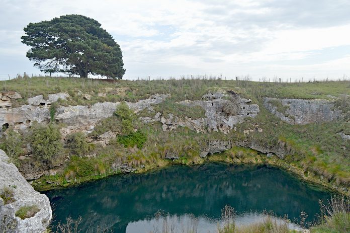
KNOWN as “One Tree” by the cave diving community, this water-filled sinkhole gained its name from a lone pine tree standing near its northern edge.
On private property in Mount Schank, it is situated in a paddock with only the large pine visible from a nearby unsealed road.
The sinkhole is a cenote – a deep, circular water-filled cavern – which is very rare around the world and only found across the Lower South East, in the Yucatan Peninsula in Mexico and in central Turkey.
Veteran cave divers and Cave Divers Association of Australia (CDAA) life members Ian Lewis and Peter “Puddles” Horne have been documenting and researching caves and sinkholes in the South East since the late 1970s, and told The Border Watch One Tree has officially been named Wurwurkooloo in early surveys of the district.
The hole itself does not become visible in the paddock until the visitor is almost at its edge, revealing its high walls and fresh water lake.
The lake is clear in winter when algae does not grow, and hazy in summer when the water is warmer.
It is around 36m in diameter with 8 to 10m high walls all around except on the southern side where a rough cutting makes access to the water level relatively easy.
Underwater, the walls initially slope towards the centre of the sinkhole before belling out, creating a large flooded cavern many times the diameter of the entrance lake above.
Once under the water’s surface, the diver normally descends to the top of a silt-covered mound at around 32m.
The mound formed when the former cave’s roof collapsed, forming a sinkhole.
Here, among barbed wire, old fencing and other farm rubbish the hole’s main attraction can be seen – an old harrow, or “The Harvester” as it is commonly known by cave divers.
“It looks like a giant hay rake with landed on its iron wheels and is very well preserved because the fresh water at depth does not corrode it.
“It’s a wonderful artefact from over a century ago and approaching it as a diver is like drifting down into a museum,” Ian said.
From here, the bottom slopes away under the walls to a flatter floor where many large boulders and the upside down wreck of an almost buried car can be seen.
The sinkhole reaches a maximum depth of around 50m, depending on water levels and features a number of “swim throughs” between the boulders.
Some graffiti can be seen on the walls, especially near the deepest area on the northern and north-western sides of the hole, made by divers many decades ago before the importance and rarity of these cenotes was fully understood.
The carved outline of a shark looming out of the darkness can be seen in one location which is the product of an early diver’s humour.
“In addition divers regularly see common galaxias (locally known as native trout), introduced red fin perch and various crustaceans, especially
the common yabbie,” Peter said.
“The first known logged scuba dives in the sinkhole took place in November 1962, when local divers Philip ‘Mick’ Potter and Jock Huxtable descended to about 45 metres.
“Some preliminary environmental studies and mapping attempts were made by myself and other cave diving colleagues in the early 1980s, resulting in a collection of useful reference information about this mysterious place.
“The CDAA has also mapped the sinkhole with the interesting outcome being a three dimensional ‘fly through’ computer map.”
Peter said the Cave Exploration Group of South Australia’s first reference to the sinkhole was by Elery Hamilton-Smith in December 1954.
“He reported a very deep lake of bright blue colour,” he said.
To ensure safe and pleasurable diving the site has been rated deep cavern by the CDAA, meaning only appropriately certified and equiped divers may use the facility after the landowner’s permission has been sought.

According to veteran cave diver Ian Lewis, Little Blue Lake as well as the One Tree and Ela Elap sinkhol
es were three cenotes discovered close together and in a line by Governor Grey when his expedition explored the Lower South East in 1844,
“The famous South Australian artist and painter, George French Angus painted several of these sinkholes in watercolours on that expedition and copies
of these can be seen in the Riddoch Art Gallery in Commercial Street,” he said.
“The paintings are the first pictorial record of the cenotes, the landscape and the vegetation at the time of very early settlement in the region.”
Ian said many cenotes in the area have similar stone ramp cuttings in their walls which were hand-dug around the late 1800s and in 1900 to allow stock to walk down to the freshwater edge to drink.
“Nowadays, the ledges are too high as the water table receded in line with the regional rainfall pattern,” he said.
“Mapping research has revealed One Tree and its two nearby neighbours are situated along the Nelson Fault line which is also in line with Mount Schank.
“Early settlers thought these three sinkholes were volcanic vents, but we later worked out they are actually limestone holes.
“The influence of the Mount Schank volcano has caused them to be deep, large and round, so in many ways the first settlers were right,” he said.


